Understanding drone no-fly zones with Kittyhawk + Mapbox
By: Rob Altenhaus
Kittyhawk, a full-stack platform for commercial drone operations, is helping UAV companies take to the skies while remaining FAA complaint with their new tool, Dynamic Airspace™.
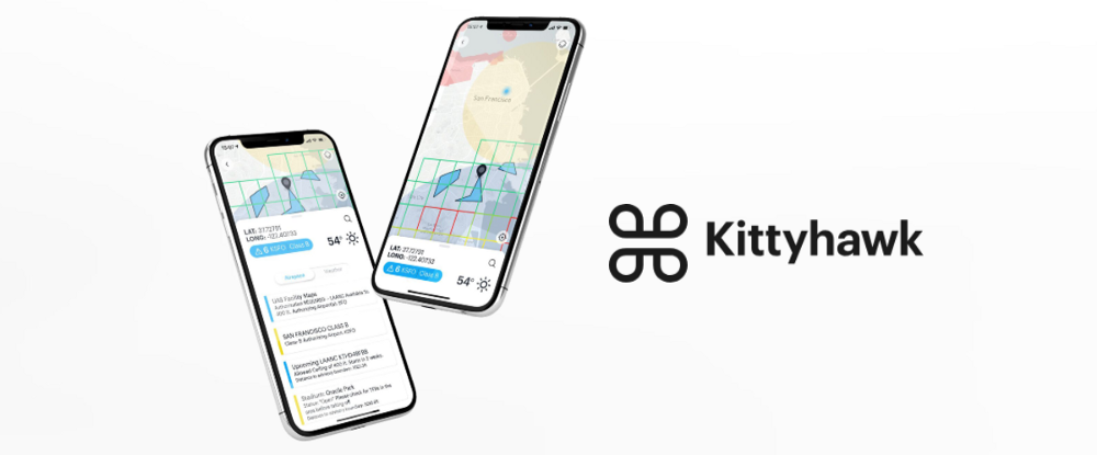
Dynamic Airspace™ helps users navigate the complex rules and regulations of aviation with customized maps of customer-specific airspace based on their location and specific needs. It personalizes the flight and regulation experience by enabling each company to look at the airspace they’re flying in, see authorizations, track the locations of their drones, view annotations, and explore the points of interest relevant to each company.
To celebrate the launch of Dynamic Airspace™, we sat down with Jon Hegranes, CEO of Kittyhawk, to hear more about how they’re building with Mapbox.
First off, can you tell us a little more about Dynamic Airspace™ and what you’re most excited about with this launch?
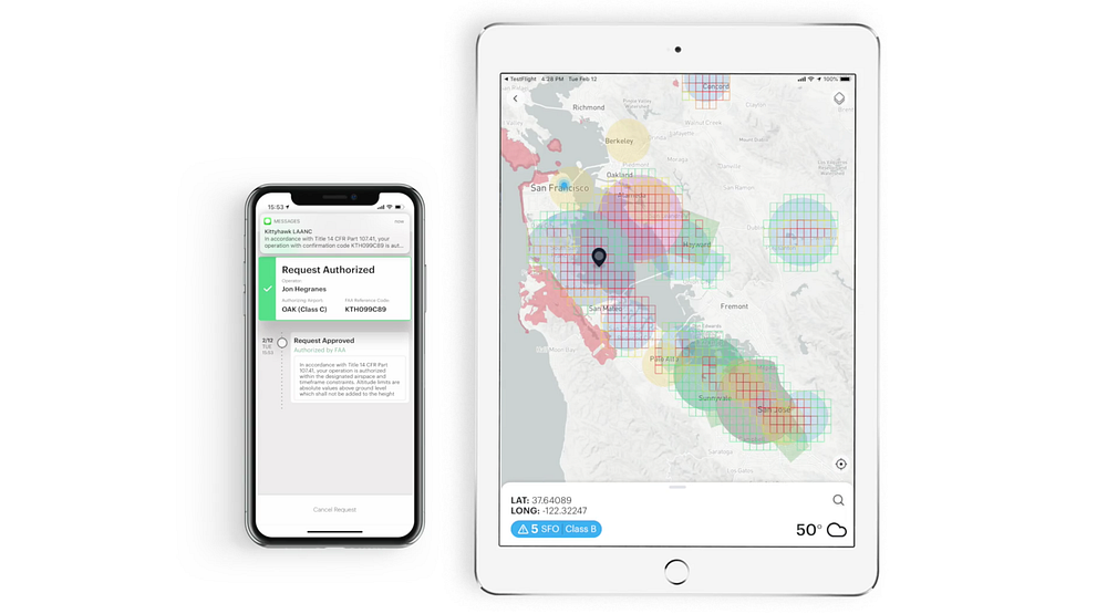
With Dynamic Airspace, we’ve combined patent pending airspace technology with Kittyhawk’s existing tools to make airspace maps dynamic. For the first time, we’ve made airspace unique and tailored to individual operators and enterprise data sets. We can now give real-time awareness to whether or not a drone flight is compliant or needs further authorization.
How do users interact with the map in Dynamic Airspace™?
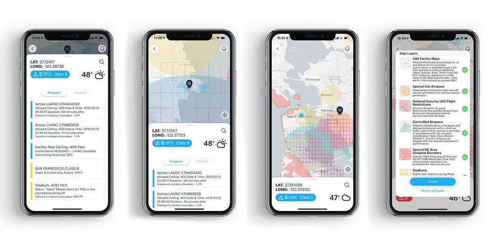
The map is the center for everything in Dynamic Airspace™. Once a user puts Dynamic Airspace™ into action across their drone program, each map layer immediately adds valuable situation awareness for their operations and their teams. Every layer of the map is segmented based on the various compliance they need to review in their controlled airspace or LAANC authorizations. In addition to all the critical airspace layers that they need to use for planning and flying safely in the national airspace — from special use airspace to UAS facility maps.
Which Mapbox tools are you using to build Dynamic Airspace™ and other Kittyhawk products? What features of our tools did you find most useful?
Some of our primary KPIs are the number of authorizations and the number of flights that happen in Kittyhawk, and Mapbox helps us make those features and workflows more useful to customers. More directly, data integrity and performance/speed are essential factors for drone operations, and the performance of the latest Mapbox SDKs made development and performance of these increasingly complex maps fast.
We’re using Mapbox across our platform on web, Android, and iOS. For our mobile applications, we use Mapbox Mobile SDKs, and in the Dynamic Airspace™ app, we’re using the Tilequery API to determine what advisories are around a requested location. Having one source for all of our data guarantees that we are consistent across all platforms.
Why did you choose Mapbox? What were your most significant needs?
When Kittyhawk first launched on iOS, we started with base Apple maps, which was fine for basic flight logging and planning, but we ran into issues when we wanted to customize and adjust the map. We also wanted to unify our solution and map development across, web, iOS, and Android. Mapbox enabled us to bring the same data and experience to our customers on any platform.
We were drawn to Mapbox initially because of how developer friendly is to get started. Excellent documentation, code samples, and a developer community enabled us to make the switch seamlessly. From then on out, our challenge has been to take full advantage of the Mapbox platform. We’ve done a lot of development around our Dynamic Airspace™ product for drones, including our FAA-Approved LAANC applications, but we’re still scratching the surface of what’s possible on Mapbox.
What’s next for Dynamic Airspace™?
We’re excited to share that as of this week the FAA chose our airspace tools as the sole provider for their B4UFly application, and will be leveraging the power of Dynamic Airspace™ for the new and improved app.
We’re also introducing LAANC-as-a-layer, to help our users see current and upcoming authorizations on their map on any device where they access Kittyhawk — including Android, iOS, and the Kittyhawk web dashboard. We’ll also be introducing a whole host of layers soon including COAs, waiver, missions, flights, and UTM data. In the future, we also want to help customers define areas of operation with details around buildings, facilities, and critical infrastructure to give their operations new ways to view airspace when planning, flying, streaming, or reporting.
Want to start flying with Kittyhawk or Dynamic Airspace? Find out more. If you’re ready to start creating your own tools or projects, sign up to start building with Mapbox.
Soruce: https://blog.mapbox.com/fly-fine-free-a04484a8c76d
Written by
Mapbox
We are a location data platform, changing the way people explore the world.